Natural England district level licensing impact assessment
Impact assessment, compensation and case studies
We have received some feedback on the Natural England-led District Level Licensing (DLL) schemes with regard to the breakdown of fees and how we calculate the cost to join the scheme. To help with this, we have put together this note to explain the principles we are working to, together with some illustrative examples.
One of District Level Licensing’s key principles is that four compensation ponds are created for every one occupied pond lost, to contribute to attaining favourable conservation status (FCS) of great crested newts (GCN). There will also be no net loss of water bodies in the landscape, so a minimum of a 1:1 ratio of ponds created to ponds lost will always be achieved. These two ratios are complimentary, not additive.
All ponds within the red line boundary of a site are considered to be lost to GCN, although they may be retained for other biodiversity reasons or planning policy. Ponds within 250m of the red line boundary are considered to be proportionally impacted. Each pond has a 250m buffer applied around it and any overlap with the red line boundary is considered lost.
There are two options for Natural England-led District Level Licensing. Both options ensure that the 4:1 ratio of compensation ponds for every occupied pond lost is met.
No survey option
Under the ‘no-survey’ option, Natural England’s pond layer and risk zone map determine the level of impact. Multipliers are then used to determine the level of compensation: In the amber zone, where we predict GCN to be present, there is a 2x compensation multiplier (to be precautionary, we have assumed that 50% of all ponds are occupied, therefore by applying this multiplier we can be confident that the 4:1 ratio will be achieved). In the green zone, where we consider GCN are likely to be absent, there is a 1x multiplier.
Survey option
If the applicant has survey information no more than four years old, it must be submitted to Natural England. The ‘survey’ route therefore takes precedence over the ‘no survey’ route, as GCN presence is known, rather than modelled. Compensation multipliers are therefore applied to each pond individually. If occupied, it is a 4x multiplier; if absent, it is a 1x multiplier. If the pond has not been surveyed (for example if it isn’t safe to do so), to be precautionary, it is a 2x multiplier.
Under the traditional licensing regime, compensation must be in place and functional before impacts can take place. Ahead of scheme launch in Strategy areas, we created/restored compensation ponds upfront. However, many of these new ponds are not yet fully established. To account for this, we have introduced a ‘time-lag’ multiplier. A further 1.1x multiplier is applied to any application which has been allocated compensation ponds under a year old.
Each compensation pond costs £15,850 + VAT. This figure covers the initial creation or restoration and includes everything required to maintain and monitor the pond in perpetuity (25 years). In addition to the Conservation Payment, a one off upfront fee of £570 + VAT is payable on issue of the Impact Assessment and Conservation Payment Certificate and a licence fee of £690 is required prior to provision of the licence.
Examples
Below are three examples of varying scale and impact, to show the level of compensation and cost required. Please note that these example maps and calculations are indicative only and an accurate impact assessment for a site can only be obtained by submitting a formal enquiry to Natural England. These examples may not be in an accessible format to request this please contact Natural England.
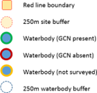
Key
Example 1: A small, low impact development using the ‘no survey’ route.
Zero ponds within the red line boundary, two ponds within 250m of the red line boundary. This development is in the amber zone.
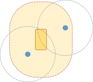
- Ponds impacted 0.2
- Amber zone multiplier (2x) 0.4
- Time lag multiplier (1.1x) 0.44
- Payment -£6,974
- VAT - £1,394.80
- Total - £8,368.80
- Plus licence fee - £9,058.80
Example 2: A medium size and impact development using the ‘survey’ route.
One occupied pond within the red line boundary, two ponds within 250m of the red line boundary, one absent and the other could not be surveyed.

- Ponds impacted - 1.2
- Total ponds required - 4.3
- Time lag multiplier (1.1x) - 4.73
- Payment - £74,970.50
- VAT - £14,994.10
- Total - £89,964.60
- Plus licence fee - £90,654.60
Example 3: A large, high impact development using the ‘no survey’ route.
Three ponds within the red line boundary, six ponds within 250m of the red line boundary. This development is in the amber zone.
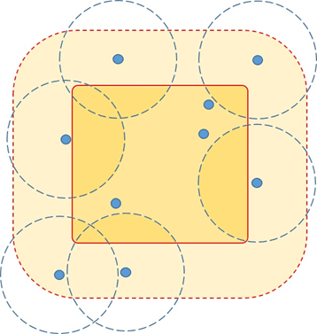
- Ponds impacted - 4.4
- Amber zone multiplier (2x) - 8.8
- Time lag multiplier (1.1x) - 9.68
- Payment - £153,428
- VAT - £30,685.60
- Total - £184,113.60
- Plus licence fee - £184,803.60